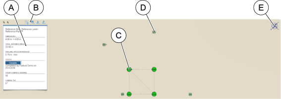
Drilling plans are listed in the Drilling Plan overview. You can open the selected drilling plan by clicking its name in the plan overview window.

The Drilling Plan view contains the following information:

| UI area | Functions | UI area | Functions |
|---|---|---|---|
| A | Drilling plan overview | D | Hole end point |
| B | View controls / data management | E | Plan orientation |
| C | Hole starting point
|
||
Note: You can change the status of the drilling plan by clicking the status button in the drilling plan overview. If you change the status to 'Complete', the date is displayed in the drilling plan overview.
Hole view
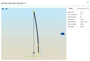
Individual boreholes can be examined by selecting a hole from the Drilling Plan view.

The following notifications about problems in borehole measurement are possible:
| Error message | Description |
|---|---|
| AzimuthUnreliable | The Azimuth measurement is not reliable. |
| TooVertical | Hole is too vertical for accurate Azimuth measurement. |
| CorruptAcceleration | Acceleration data is corrupt. |
| TooFastRotations | Too fast rotations during borehole measurement. |
These notifications are also included in exported borehole reports.